Hollandia
Tekst van Vademecum voor Nederlands-Nieuw-Guinea, 1956 komt binnenkort!
Hollandia, Capital of the subdivision of the same name.
Source: Handbook on Netherlands New Guinea, 1958
| Population |
Papuans |
Europeans |
Asiatics |
Total |
| Subdivision |
29,845 |
8,195 |
1,532 |
39,572 |
| Capital |
6,412 |
7,635 |
1,106 |
15,153 |
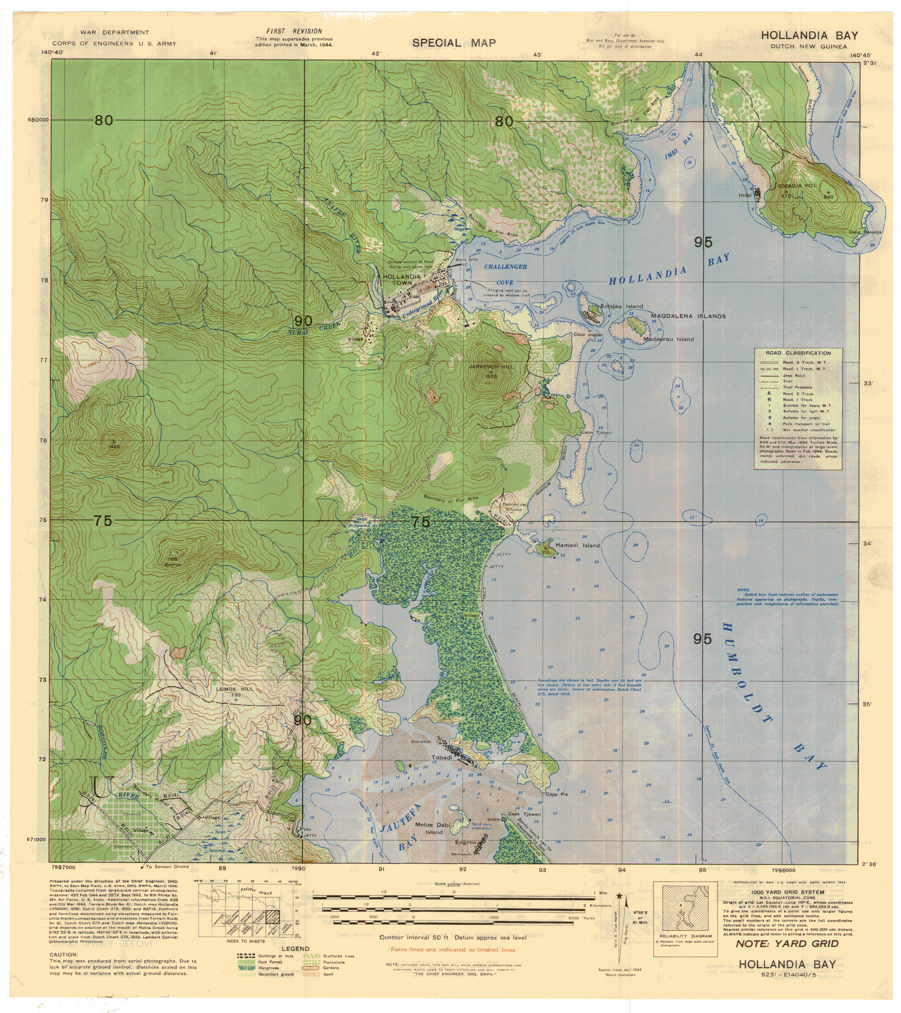
Pre-war Hollandia, a small settlement and duty station of a district officer, was located in what is
presently known as "the gulf". It was wiped out by air raids before and during the American landings in
1944, not a single house was left erect.
Subsequently the Americans built an enormous base, called "Base G" (which succeeded "Base F" at
Finchhafen). "Base G" at first used to lie within reach of the Japanese air force. In order to minimize
possible damage by enemy air raids, base G's various installations and structures had been built as far
away from one another as possible. The base therefore stretched from Tanah Merah, the oil supply depot, to
Cape Suadja, which housed the administrative center of the base, also known as subdivision Base G. The
tactical headquarters were originally located at Joka on Lake Sentani, subsequently near Hol Tekang. When
General MacArthur moved his General Headquarters from Brisbane to Hollandia, it was established at a place
still called "MacArthur Hill". Downhill, at what is now known as "Ifar", the Seventh Fleet Recreation
Center (for officers) had been built.
The three air fields already built by the Japanese were improved and enlarged and all sorts of sheds
and buildings were added. Some mobile hospitals were moved in immediately. At a later time, when Hollandia
had already become a "rear area", two large hospitals with a total accommodation of about 2,000 beds were
constructed next to each other. Near Kotaradja was the Quartermaster area, including a large ice plant.
General MacArthur's large radio station was situated at Skyline; the slopes, with what is now Noordwijk,
were then known as Signal Hill, radio station of the Navy. What is presently known as "the wharf"
(Government repair yards), then was a complete "destroyer repair base" while also the entire strip along
the coast of Jautefa Bay was used by the United States Navy. Along Humboldt Bay eight docks had been
constructed, each with accommodation for ships of up to 10,000 tons.
The NICA - Netherland Indies Civil Administration - was assigned a permanent place in Jabau Valley,
nowadays still known as Kotanica.
Because of having been military headquarters originally, the present city of Hollandia presents a
peculiar picture. When the Americans left, the most serviceable buildings were taken over for use by the
various bureaus of the Residency.
Most of the war supplies were taken over by a foundation, popularly called "basis". As they were
stored near the port, that part of Hollandia situated along the waterfront now still goes by the name of
"basis".
Kotanica soon became uninhabitable. Consisting entirely of wooden structures (built of atap and
Gaba-Gaba), it was also greatly exposed to the danger of fire. Therefore, already in 1946 it was decided
to move the Kotanica establishment, offices and living quarters and all, into the two empty large
hospitals. This set-up representing the capital of the Residency was first called Kotabaru, later it went
by the name of Hollandia-Stad and now it is styled Hollandia-Binnen (Hollandia-Interior).
General MacArthur's headquarters on the hill were demolished. The General's house itself had been
taken apart and was rebuilt at Kotabaru as the Resident officer's official residence; later it became the
official residence of the Governor.
Later some thought was given to the possibility of moving the Kotabaru establishment to the Seventh
Fleet Recreation Center, a group of buildings pleasantly situated at an elevation of 1,000 feet. However,
the Administration did not have the necessary means of transportation and at a later date these buildings
were occupied by the army.
The New Guinea Police Training School was given quarters at "Base G" and is still located there.
The personnel of the "basis" found accommodation in existing quarters near the waterfront. Tanah Merah did
no longer serve any purpose; its tank yards were dismantled and the road leading to it soon became
dilapidated because of heavy rains.
Such is the remarkable story why Netherlands New Guinea's Capital spreads out over a distance of some
twentyfive miles.
It also explains why this town, a village according to Netherlands standards, has a road system of
approximately fifty miles and has so much motorized traffic. The long distances make it imperative.
Until now, Hollandia has no economic significance. It is merely a small residential town of civil
service employees and this determines the scope of its small industrial, agricultural and market-gardening
activities.
It goes without saying that "savage" Papuans are no longer to be found in the vicinity of Hollandia.
The indigenous population has for a long time been in close contact with modern civilization.
Hollandia (from 1910 to 1962) the capital, in the Northeast, became "Kotabaru" from October
1, 1962 till May 1, 1963; "Sukarnopura" till the end of 1968; "Abepura" till March 1969; and is now
called "Djajapura" or "Jayapura".
Links naar photo's en verhalen komen binnenkort.
Hollandia Bay 1944 (Source: Papua Map Index)
 Hollandia (Schoolatlas van Nieuw Guinea door drs. H. Eggink, W. versluys NV, Amsterdam, 1956)
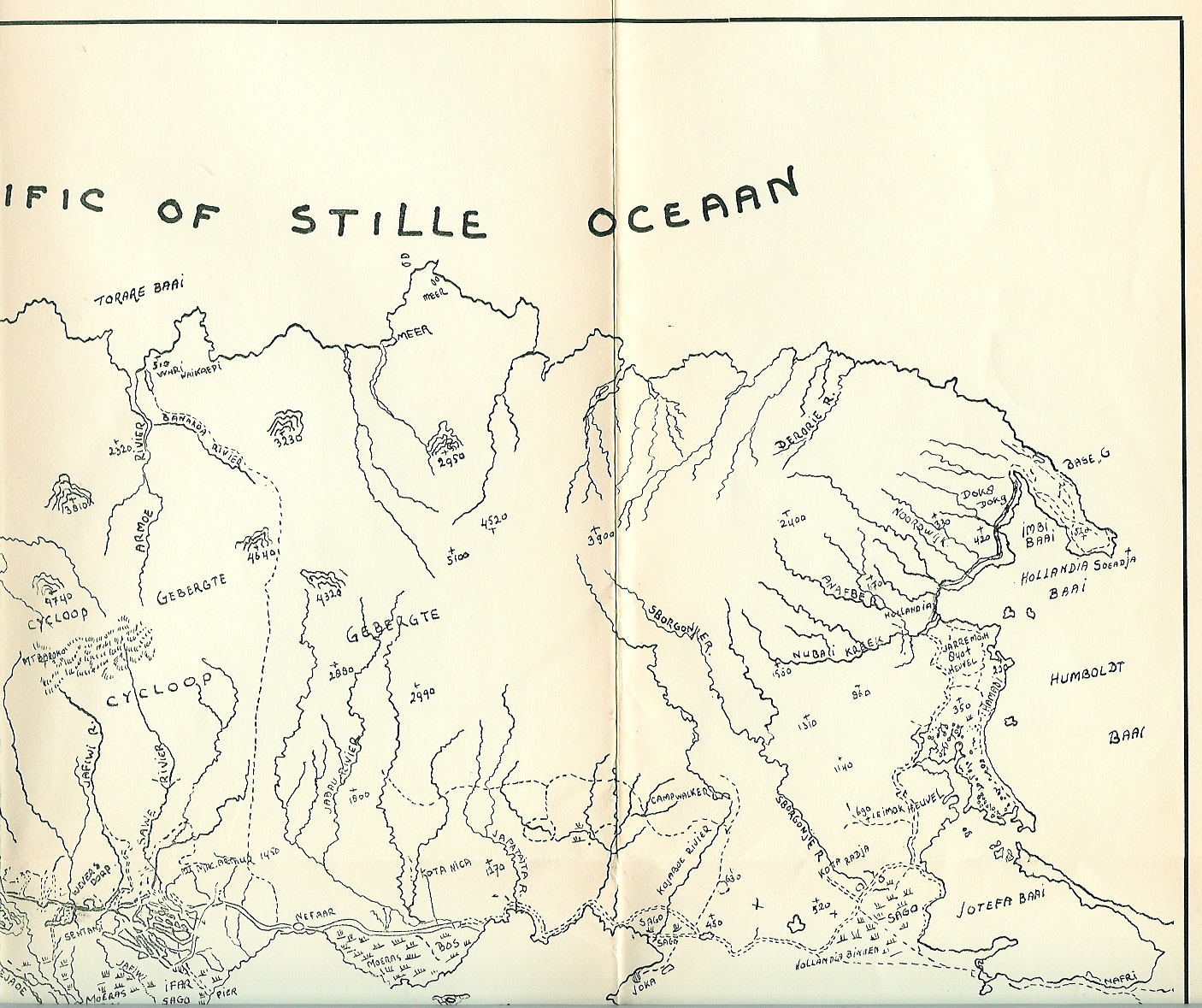
 Hollandia 50 jaar (Schets: Hollandia 50 jaar, van 7 maart 1910 tot 7 maart 1960 (half; van Cycloop gebergte tot Base G)
 Links to photos and stories to follow soon.
Hollandia
Back to Towns and Villages
Links to photos and stories to follow soon.
Hollandia
Back to Towns and Villages
Last updated November 24, 2004 |
|
|
|
|
|